The Cuckoo Wasps – some of nature’s artworks

More Lockyer Valley wildlife

Large Cuckoo Wasp – Stilbum cyanurum (Vinegar Hill)

Some of the most spectacular wildlife in the Lockyer Valley isn’t necessarily the big stuff like kanagroos, koalas or kookaburras.  The small stuff can be absolutely entrancing.

The Large Cuckoo Wasp above is one example.  It was found dead on the floor in our house (hence the bits of detritus caught up in its exoskeleton).  Before you start thinking that we are a bit casual with our housekeeping, the critter itself is less than 20mm long, so the “fluff” is actually fairly minute particles.  Having said that this species is so small, it is known as the Large Cuckoo Wasp, which suggests that in general Cuckoo Wasps are pretty small insects.

Just how small they are can be seen in the image below.

20160103_Cuckoo Wasp_GFC_P1000969_small

The individual in the photo at the top of this page is on the right here. The one on the left is a different species (one of the two shown below). This Australian 20 cent coin has a diameter of 28mm.

The females of these wasps parasitise the nests of mud wasps, laying their egg in the mud nest next to that of the host species.  If they are discovered in the nest they roll into a ball like an armadillo, to protect themselves from the sting of their much larger host with the armour plates of their outer skeleton.  It seems to be a common feature of Cuckoo Wasps that the surface of the exoskeleton is pitted; perhaps to increase its strength, or to foil the probing sting of an angry mud wasp?  The defensive posture is often also used if they are threatened in some other way – such as a human trying to capture them.

The “appendage” at the rear is the ovipositor, used for laying eggs.  I’m curious about the structure of this ovipositor – you’d think that an insect that just lays its egg in the open nest of another wasp wouldn’t need something as robust as this to do the job.  Some other species of parasitic wasp have large teeth on the ovipositor in order to ‘drill’ through wood to reach their host(1).  For example, in the sawflies the ovipositor is saw-like and is used to insert the eggs into plant leaves, stems or wood(2).  Is this a relic from a previous evolutionary stage?

Large Cuckoo Wasps feed on the nectar of flowers in the woodlands, heaths and urban areas which are their habitat.

For a beautiful image of this species, have a look at this shot from Stanley and Kaisa Breeden.

After we found the second, smaller Cuckoo Wasp (dead on a window ledge in the house), and than another small one, I contacted Ken Walker at Museum Victoria and offered to send him the specimens to be identified.  Ken was happy to do this and to send me photos of the specimens.

Not only did Ken take fantastic photos, he also spent a lot of time cleaning up all the dust and debris off the specimens and then “relaxing” them so that they could be properly displayed.  Compare the photo on the left immediately below to the one at the top of this post – they are the same specimen.

Here are some of his photos.  These are photos of the most “diagnostic” parts of the bodies.  The scale bars for the whole body photos are 5mm for the top photo and 2mm for each of the others.

Stilbum cyanurum

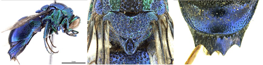
Stilbum cyanurum (Photo Ken Walker)

Praestochrysis lusca

Praestochrysis lusca (Photo Ken Walker)


Chrysis lincea

Chrysis lincea (Photo Ken Walker)

You can find more about this species at the following links:

http://www.brisbaneinsects.com/brisbane_parawasps/CuckooWasp.htm

https://baynature.org/articles/the-cuckoo-wasp-a-gorgeous-parasite/

http://anic.ento.csiro.au/insectfamilies/biota_details.aspx?OrderID=27447&BiotaID=29790&PageID=families

(1) http://bugs.bio.usyd.edu.au/learning/resources/Entomology/externalMorphology/imagePages/ovipositor.html

(2) http://www.qm.qld.gov.au/Find+out+about/Animals+of+Queensland/Insects/Wasps+and+bees

http://www.bowerbird.org.au/observations/60098

Thanks to Ken Walker from Museum Victoria for his willing assistance with identifying these species, and for the many other times when he has provided helpful advice on invertebrate wildlife.  Ken is the driving force behind Bowerbird, a huge job which he undertakes in addition to his many other duties, and he manages to produce the monthly issue of the Bowerbird Bugle newsletter.

Not in my backyard? How to live alongside flying-foxes in urban Australia

Justin Welbergen, Western Sydney University and Peggy Eby, UNSW Australia

The conflict between urbanites and wildlife recently developed a new battleground: the small coastal New South Wales town of Batemans Bay, where the exceptional flowering of spotted gums has attracted a huge influx of grey-headed flying-foxes from across Australia’s southeast.

In response to intense and highly publicised community concern, federal Environment Minister Greg Hunt has announced he will seek an immediate National Interest Exemption to facilitate dispersal of these bats – a move that risks undermining legal protections afforded to this and other threatened species.

Similar conflicts are occurring elsewhere in NSW, such as the Hunter region, where some unscrupulous members of the public lit a fire in a flying-fox roost at Cessnock.

With the ongoing expansion of the human urban footprint, animals are increasingly confronted with urban environments. Human encroachment into natural habitats generally negatively affects biodiversity. However, urban landscapes can present wildlife with an irresistible lure of reliable food supplies and other resources. While urban wildlife can provide a range of benefits to health and wellbeing, it can also be cause for frustration and conflict.

Urban human-wildlife conflict is a growing area of management concern and scientific research. But the research suggests that the current strategies for addressing NSW’s conflicts between humans and flying-foxes might not have the intended results.

Flying-foxes increasingly find themselves in urban areas.
Justin Welbergen

Ruling the urban roost

Australian flying-foxes are becoming more urbanised, and the noise, smell and droppings from their roosts can have huge impacts on local residents.

A fundamental problem underlying current approaches to urban roosts is a lack of understanding of the extraordinary mobility of flying-foxes. They are some of the most mobile animals in Australia, with movements that range from foraging trips of up to 120 km in a single night to long-distance nomadism covering thousands of kilometres in a single year.

Nomadic movements of an adult female grey-headed flying-fox, tracked over a period of four years and currently at Batemans Bay.
John Martin & Justin Welbergen, unpublished

While roosts can remain active for decades, they are more like backpacker hostels than stable households, housing a constantly changing clientele that comes to visit local attractions. Roosts are connected into large networks through which flying-foxes move in response to changes in local food resources.

This explains the sudden influx in places such as Batemans Bay where preferred food suddenly becomes abundant. But it also highlights the importance of a national approach to flying-fox management and conservation.

Intense local flowerings of Eucalypts, such as spotted gums, produce copious amounts of nectar and pollen, which attract large numbers of flying-foxes and other species for several weeks. When a relatively small local flying-fox population that is tolerated by its human neighbours suddenly increases tenfold, it can place severe pressure on the local community.

Despite their transient nature, these influxes are often wrongly interpreted as population explosions, leading to calls for culling. In comparison, more humane tactics – such as using loud noise or vegetation removal to disperse the flying-foxes – can seem like a more balanced response. But does dispersal actually work?

Council workers in Charters Towers, Queensland, using ‘foggers’ to disperse flying-foxes from a local roost.
Australasian Bats Society

Shifting the problem elsewhere

There is now ample evidence to show that dispersals are extremely costly and can exacerbate the very human-wildlife conflict that they aim to resolve.

Most dispersals result in the flying-foxes returning the original roost as soon as the dispersal program ends, because naïve new individuals continue to arrive from elsewhere. Overcoming this can take months or years of repeated daily dispersal.

Other dispersals result in flying-foxes establishing new roosts a few hundred metres away, typically within the same urban environment in locations that we cannot control. This risks shifting the problem to previously unaffected members of a community and to other communities nearby.

Former flying-fox roost at Boonah, Queensland, that contained thousands of flying-foxes before it was destroyed in June 2014.
Justin Welbergen

While flying-foxes are often portrayed as noisy pests, they serve our economic interest by providing irreplaceable pollination and seed-dispersal services for free. What’s more, those same bats that annoy people during the day work tirelessly at night to maintain the health of our fragmented forests and natural ecosystems.

So it is in our national interest to manage conflict at urban roosts, by using approaches that balance community concerns with environmental considerations.

Flying-foxes perform irreplaceable ecological roles in our natural environment.
Steve Parish

To be considered “successful”, a dispersal should permanently reduce conflict to a level that is acceptable to the community without causing significant harm to the animals. However, dispersals are currently implemented at the local council level with little or no monitoring of the impacts in or outside the immediately affected area. This makes it hard to assess whether they have been successful.

For example, it is not uncommon for flowering to cease and flying-fox numbers to decline naturally during the period of active dispersal. This gives the community a false sense that a permanent solution has been achieved, when in fact the issues will recur the next time the trees blossom. There is thus an urgent need for urban roosts to be managed with properly defined and applied criteria for success.

Evidence-based management

Unfortunately, lack of research effort directed at “ugly” and “less popular” Australian animals means that very few evidence-based management tools are available to deal with contentious roosts.

Research targeting a few key areas would greatly help efforts to improve urban roost management. For instance, we do not know how flying-foxes choose their roost sites, which leaves us unable to design “carrot solutions” by creating more attractive roost sites elsewhere.

Intensive tree-flowering events are relatively infrequent and hard to predict. This means that it is difficult to prepare communities for a sudden influx of flying-foxes.

Furthermore, the acceptability of various flying-fox management options differs between sections of the community, so it is difficult to find optimal solutions. Social scientists are currently trying to help identify priority areas that promote long-term viability of flying-foxes while also easing conflict with humans.

The extreme mobility of flying-foxes means that a uniform federal approach for management is needed.
Justin Welbergen/WildPhotos.org

Local, state and federal governments continue to allocate considerable funds for dispersal responses, even though such actions are high-risk activities for local communities and are unlikely to provide long-term solutions. We argue strongly that targeted research is needed to better inform land managers and affected communities of flying-fox ecology and provide them with low-cost, low-risk, evidence-based tools for dealing with urban roosts.

Flying-foxes don’t care about legislative borders, and state-based responsibility for wildlife management leads to discontinuity in approaches between jurisdictions. While flying-foxes are being monitored at the national scale, this initiative needs to be combined with a uniform federal approach for managing flying-foxes in our human landscapes. Otherwise, conflicts such as those faced by the residents of Batemans Bay will continue unabated.

The Conversation

Justin Welbergen, Senior Lecturer in Animal Ecology, Western Sydney University and Peggy Eby, Adjunct Senior Lecturer, Centre for Ecosystem Science, UNSW Australia

This article was originally published on The Conversation. Read the original article.

Motocross traffic on Adare Road – we stand to lose more than you think

I’ve posted before about the unsuitability of Adare Road for large amounts of traffic.

There’s more to that issue and I’ll come back to it in another post.

There are unsuspected losses associated with traffic on Adare Road that we face if the proposed motocross development is allowed to go ahead.

One of these relates to the Gatton Light Horse Troop.  You might be familiar with their role in the Anzac Day celebrations in Gatton and other localities in the Lockyer Valley.

The Gatton Light Horse Troop in the Anzac Day parade in 2012.  A friend in Germany sent this to me, which shows how far the knowledge of our Light Horse Troop has spread.

The Gatton Light Horse Troop in the Anzac Day parade in 2012. A friend in Germany sent this to me, which shows how far the knowledge of our Light Horse Troop has spread.

What you wouldn’t know, unless you are out toward the end of Adare Road early on a Saturday or Sunday, is that the Horse Paddock beside Adare Road,on the right just before the Redbank Creek Crossing, is one of their training grounds.

It's a stirring sight to see them practising mounted military manoeuvres at full speed.

It’s a stirring sight to see them practising mounted military manoeuvres at full speed.

If there are up to 150 vehicles travelling down Adare Road on a Saturday or Sunday morning, the Horse Paddock will become unsuitable for Light Horse training exercises.

There’s another group in the community (this time a much wider community) who know of the Adare Road Horse Paddock.  They are the birdwatchers, and the trees and bushes around the edges of the Horse Paddock are one of several regular birding spots for many visitors.

Adare road has been visited with increasing regularity by local, Brisbane, interstate and overseas birders over the last 20 years.  The location features regularly in online lists of the interesting or rare species which have been seen there.

IMG_0056-1

Two of the visitors in this group were from Japan

It continues to be something of a ‘hot-spot’ where visitors can find a selection of scarcer species which can be difficult to locate elsewhere in the region.  The combination of open woodland, riparian vegetation where Redbank Creek crosses the road, open paddocks, and the dams along the road provides for a range of habitats and therefore bird species that isn’t easily found in a situation where it is easily viewable from the road. And there’s always the possibility of seeing a koala, especially at the Redbank Creek crossing.

There are many birdwatchers who visit Adare Road regularly, some every couple of months, some every week.  There are also bird clubs which make annual trips to the area.

A lot of the most interesting birding is done along the road verges, including along the sides of the Redbank Creek crossing.  Motocross traffic in the mornings and evenings (when most birders visit) is going to turn birdwatching along Adare Road into an extreme sport – not to mention being extremely unpleasant with all the dust and noise.  It can be pretty confidently predicted that the beginning of motocross traffic will be the beginning of the end of birdwatching on Adare Road.

Revealing a significant koala population in the Adare-Vinegar Hill area

Koalas are probably the most environmentally significant species that would be impacted by the establishment and operation of a motocross track on the Adare property.   Impacts will come from noise, vehicle strike and possibly vegetation clearing in Stage 2 of the development.

It’s funny how members of a community can individually recognise that they have an unusual number of koalas in their vicinity, but no one actually comes to the conclusion that there is an unusually large koala population in the local area.  This is another aspect of our environment/community that dealing with the motocross proposal has brought to the fore.

The database

For the last few weeks our group has been collecting incidental records of koala sightings in the area of bushland which is contiguous with the vegetation in the vicinity of the proposed Adare motocross track.

We now have 66 records of koala sightings for this area.  It may not look like 66 “pins” on the map, but that’s because at this scale many pins are hidden behind others.

These sightings are all within 5km of the motocross track, and almost all are within less than 4km.  The nearest is only 950 metres from the track.

All of these sightings are in vegetation types that occur on the motocross property and within 20-70 metres of the track.  These vegetation types are classified as Bushland Koala Habitat or as Essential Habitat for koalas.

Remember, these are incidental sightings. They are not the result of targeted surveys for koalas.  They are sightings that people happened to make while they were doing other things, and which they have some record of.  People don’t tend to look up in trees when they are working on their land.  Even if they do, koalas are pretty cryptically marked.  They have colours which tend to blend with the bark of trees and the dark shadows in thick foliage, and they even have lighter patches around their rear ends, so that their silhouette is broken up when seen against the sky from below.  Most people never see a koala when they are walking through the bush.

Our data collection is not yet complete.  The properties where there are no koala records are almost all ones where we haven’t yet tried to collect information or where we don’t have access.

The Road-kill Threat

Death by vehicle strike is among the three greatest threats to koala populations in Southeast Queensland.

Adare Road runs from the big dam just to the right of bottom centre in the map vertically (north) to the entrance to the motocross track. There are more than 30 records of koalas within 250 metres of Adare Road (four of these are of koalas crossing the road, and one is of a dead koala on the road).

Koalas are active at night, and that’s when they will be crossing the road.  Imagine the number of road-killed koalas there will be if there is motocross traffic on Adare Road four to six nights per week!

Comparison Between Our Data and the Government Database

The WildNet database has been built up by the State government over a number of years. It contains records of wildlife sightings and listings of plants, mammals, birds, amphibians, reptiles, freshwater fish, sharks and rays, butterflies and other priority invertebrates in Queensland.

The wildlife lists are based on collated species lists and wildlife records from Queensland Government departments and external organisations. The data sources include:

  • specimen collections;
  • research and monitoring programs;
  • inventory programs including extension activities;
  • literature records;
  • wildlife permit returns; and
  • community wildlife recording programs.

WildNet at present has 65 records of koalas within 10km of the motocross track.  In only a few weeks members of our group, with the cooperation of the local community, have gathered 66 records within 5km of the track.  That’s a fantastic effort, and it’s not finished yet.

It’s not that the koalas weren’t there before – just that this is a big State and there has never been sufficient resources to carry out the necessary surveys at the scale we need for dealing with local government planning applications.

Ultimately our records will go into the WildNet database and into the privately funded Koala Tracker database.

Is there no end to the pasture grass assault on the Australian environment?

One of the things that really depresses me when I think seriously about the mangement of our 33 hectares of native bushland is the problem of pasture grasses gone feral.  Green Panic is the major problem here, but we have a number of others, including Rhodes Grass.  Both were introduced into Australia as pasture plants.

The Green Panic (Panicum maximum var. trichoglume) is still touted as a good pasture grass.  The story when it was introduced was that it would not spread and become a pest because it needs plenty of moisture and will not grow under shade. Did the agronomists not know about evolution? Did they not know that a grass often has weedy characteristics because it is inherently capable of rapid adaptation to different environments.

Just in case there are agronomists or botanists who were involved in the introduction of this wonder grass among my readers: We have a new variety of Green Panic – Lockyer Valley Green Panic.  It has adapted and evolved (surprise!) and now grows even on dry ridges and under semi-closed woodland trees.  And, like all Green Panic, it grows dense and tall when it isn’t grazed, so that it crowds out the native grasses and by the middle of summer when it has dried out it forms a near explosve compact mass of cellulose that will send flames into the tree canopy.  Where previously there was a carpet of low green Kangaroo Grass on the woodland floor, now in parts of the Lockyer Valley Region we have dense tall brown monocultures of Panic.  Kangaroo Grass is unusual because it has green growth at the height of summer, and with this and its short tussocks it not only makes for some of the most beautiful Australian woodland that I know of, it also burns cool and recovers fast. [sorry for the lack of photos, for the moment I can’t find any pics of our Kangaroos Grass areas].

One of my fondest dreams is that I will see the day when communities across Australia come together in a class action against government agencies and agricultural companies, claiming massive damages for the harm done to the Australian environment by non-native pasture grasses.  So you can see why I was very heartened to see an article in todays Australian edition of The Conversation about the harm pasture grassed do.

Here’s an excerpt:

Feed or weed? New pastures are sowing problems for the future

Weeds cost Australian farmers around A$4 billion every year — and they are likely to do a similar amount of damage to the environment.

In a new global survey published this week in Proceedings of the National Academy of Sciences, we show that new pasture plants, such as grasses, present a substantial weed risk.

And despite the risk, new varieties of plants that are known to be invasive are still widely developed and sold in Australia, with little regulation from government.

So, how can we tighten control to prevent the future spread of invasive plants?

Grasses out of control

African lovegrass was used to “improve pasture” in Australia for almost 100 years, but now it is a declared weed in four Australian states and the ACT. African lovegrass has been of little value in pastures, poses a substantial fire risk and threatens a range of native species.

Similarly, Gamba grass was widely promoted by the cattle industry and government in northern Australia, but is now listed as a Weed of National Significance. Gamba grass increases fire intensity five-fold, which transforms native woodlands into exotic grassland and increases the cost of fire management by an order of magnitude.

Introducing these pasture species was a big mistake that Australians will continue to pay for indefinitely. We face increased fire risks, increased management and weed control costs, as well as ongoing loss of our natural heritage.

Have we learned our lesson?

Not yet. Agribusinesses still develop and promote new varieties of species, which are known invasive weeds.

Our new survey of pasture plants reveals that over 90% of taxa developed and sold by agribusinesses are weeds somewhere in the world, and on average 30% are weeds in the country in which they are promoted.

In Australia, these species include Orchardgrass (Dactylis glomerata), Canary-grass (Phalaris species), Tall fescue (Schedonorus arundinaceus), and sub-terranean clover (Trifolium subterraneum). These species are all recognised weeds in Australia, and all promoted by agribusiness for pasture.

Inadvertently breeding super-weeds

These species have already spread throughout much of Australia. But new varieties of the same species can be just as bad, if not worse.

Although they belong to the same species, these varieties can be quite distinct from their parents – just think of the differences between dog varieties like Chihuahuas, Dalmatians and wolves.

The impacts of new pasture varieties in the environment can be substantial, as emphasised in a report “Weed risk set to rise”, to be published this week by the Ecological Society of Australia.

New varieties can be created by cross-breeding different varieties or different species. Another trick to create better performing plants is to manipulate the symbiotic bacteria and fungi that live inside the plants. Engineering plants in any of these ways can lead to varieties with higher reproduction, higher growth rates, better resistance to disease and higher tolerance of environmental extremes.

Unfortunately (but perhaps not surprisingly), these are the same characteristics associated with invasive species. New varieties of pasture plants are bred to grow great pasture, but at the same time, they are inadvertently bred to be super-weeds, perfectly-matched to their environment and planted widely across the landscape.

Producing enormous amounts of pollen and seeds, these new pasture plants can spread quickly and over vast areas, making them very expensive to control if and when they become invasive. So it makes sense to nip the problem in the bud.

You can read the whole article here.


Madeira Vine – a permaculture food plant, or a rampant and destructive invasive?

If you’ve been reading my blog for a while you will know that I’m very concerned about the encouragement of the use of invasive or potentially invasive species in permaculture (you can see where I’ve written on the subject here and here).

Now the folks at Milkwood Permaculture have thrown up a curly one – they’ve just posted on how Madeira Vine not only has edible leaves and tubers, but is widely eaten and cultivated in Japan, where it is known as “land seaweed” (okawakame)

Typical effect of unchecked Madeira Vine [from Milkwood Permaculture blog]

As they point out, Madeira Vine is an already “adapted, perennial, zero footprint and highly nutritious food plant” with the following characteristics which are desirable in a food plant:

  • “It grows without much assistance, is hardy and produces prolifically.
  • It requires minimal cultivation.
  • It dominates an area where it is planted (meaning far less weed control is needed)
  • It is spread only* by humans and by water flows distributing the bubils – an easy factor to contain with good design.”

The Milkwood guys are  planning on having it as a food plant in their garden.  They recognise that it is a potential problem, and will manage it by eating it and stopping it from spreading.

So, should we incorporate Madeira Vine into our permaculture food production?

My first question would be: Just how weedy/invasive is it really?

Madeira vine grows prolifically at rates of up to 1 m per week in high-light environments.  It produces large numbers of subterranean and aerial tubers that not only act as reproductive bodies, but also provide the plant with a carbohydrate source that enables it to survive through difficult times. As a consequence, Madeira vine can tolerate a range of adverse conditions including drought, snow and frost, and it has been found growing in areas as diverse as rainforests, riparian fringes, rocky outcrops and frontal dunes (source).  This same ability to tolerate adverse conditions also means that the tubers can survive for very long periods of time in suspended animation, before they experience the right conditions to shoot (source).

The vine reproduces through the proliferation of aerial tubers and also from rhizome (subterranean tuber) fragments that may be broken off (source).  The aerial tubers can persist for two to 15 years and rhizomes for five to 10 years, with tuber germination rates of up to 70 per cent (source).  Although Madeira Vine is widely believed not to set seed in Australia, up to 5% of dried flowers collected from southeast Queensland were found to contain germinable seed (see #Vivian-Smith et al, below).

Dispersal is believed to occur primarily* via human spread (cultivation for ornamental purposes, disposal of vegetative material and tubers, e.g. in green waste (source), or being spread by machinery and/or gravel during road construction).  However it also spreads downslope under the influence of gravity and water movement from ridges and down watershed, and via floods (source).

Saying that it is spread primarily by humans needs to be considered in relation to just how widespread it is, what a significant destroyer of habitats it is once established, and how extremely difficult it is to eradicate once established.  Here is how the Environment Australia weeds database summarises the facts about Madeira Vine:

Madeira Vine is a Weed of National Significance (WONS). It is regarded as one of the worst weeds in Australia because of its invasiveness, potential for spread, and economic and environmental impacts.

Madeira Vine has aggressive vegetative growth which competes with and replaces other vegetation, and is difficult to control once established. Its aggressive nature gives it the potential to smother other desirable plants. Its sheer weight is capable of breaking branches off trees, thereby reducing them to poles, potentially causing collapse of the rainforest canopy (ISSG 2006). It restricts light and thereby prevents germination of desirable native species (Harley undated).

Should we then include Madeira Vine in permaculture food production?  I think there are two things to take into account before making a decision on this.

First, the permaculture ethics of care for the Earth and care for people.  The potential impacts on the Earth from Madeira Vine escapes are obvious (see the sources and photo above) and well documented, as are its impacts on the people whose properties and amenity are impacted.

Second, based on an assessment of invasiveness and impact, Madeira vine was ranked 5th worst of1060 naturalised south-east Queensland plant species (#Batianoff & Butler, below).  How are you going to ensure that:

  • no seed is set, and neither seed nor tuber material is distributed by animals, or other agents of dispersal, including water (i.e. the area where you will grow it will never flood or be exposed to high volumes of water runoff;
  • everyone who works on your garden or caretakes for you while you are away is as careful as you would be not to allow any dispersal of aerial tubers, (fragments of) rhizomes or seeds;
  • before you move on, you will have somehow removed all aerial tubers and every last fragment of rhizome before you leave, or failing this, you have some guarantee that the next landholder is going to take the same careful management approach as you?

– – – – – – – –

*I consider the statement that it is spread “only by humans and by water flows distributing the bubils – an easy factor to contain with good design” to be dangerously simplistic for a number of reasons.  First, once a Madeira Vine has established itself in a vegetated area it does not sit and wait for humans or water flows to come along and move its tubers or rhizomes.  The tubers are spread naturally when they fall from the adult plants where they have climbed up and across the canopy (often a considerable distance) from where they originally grew. Second, anywhere that an established population of Madeira Vine grows over a waterway that even only occasionally flows, this will distribute the plant to any and all areas downstream.  Third, saying that it is spread “by humans” without mentioning the many ways in which human activity can spread the plant, or the very long viability period of the tubers, gives a very misleading impression of the ease with which human activity can (even unwittingly) result in spread.

Here is a rather more informative account of how it is spread:

The most common means of reproduction and spread is via asexual tubers formed on the roots and stems. Prolific numbers of aerial tubers are produced throughout the year, which drop to the ground when mature or in response to stress. Research indicates that aerial tubers can persist for two to 15 years and subterranean tubers for five to 10 years, with tuber germination rates of up to 70 per cent. In areas of heavy infestation, soil tuber densities are up to 1500 per m2. Madeira vine is also capable of shooting from sections of severed vine.

Dispersal occurs primarily via human spread such as cultivation for ornamental purposes, disposal in green waste, or spread by machinery during road construction. It can also spread via gravity and water movement from ridges and watersheds or during floods. Mammals and birds may also play a minor role in localised spread.
While seed production is believed to be rare in Australia, research indicates that up to 5 per cent of dried flowers collected from southeast Queensland contain germinable seed. It is speculated that seed set and germination may only occur under ideal environmental and seasonal conditions.

 Sources which aren’t linked above:

#Vivian-Smith et al, Alan Fletcher Research Station QLD Unpublished data (cited in this source)

#Batianoff, G.N. and Butler, D.W. (2002). Assessment of invasive naturalized plants in south- east Queensland. Plant Protection Quarterly 17: 27–34.


Imported Weeds and Invasive Exotic Plant Species

The use of “weedy” species, together with the use of non-local species of unknown weediness, incites very heated debate in permaculture circles, inspiring a lot of name-calling and pseduo-science.  My own view is that the promotion of known invasive, or potentially invasive, species as part of the permaculture approach is highly irresponsible and arguments for their use are often couched in language that approaches the mysticism or spirituality that is supposedly “banned” in serious permaculture.  (You can see my views on the use of Leucaena here.)

Of course, the topic of invasive species overlaps with the consideration of “weeds” as an element of food productions activities.  I’m not going to go into that here, but the eXtension website has an excellent article on weeds in agriculture (An Ecological Understanding of Weeds) that incorporates both the negative and positive aspects of weeds in agriculture.  Well worth reading – much of it reads as if it was written by an well-informed permaculturist.  In fact the author, Dr Mark Schonbeck, is credited by the the Virginia Association for Biological Farming as combining “deep scientific knowledge, practical farming technique and policy smarts”.  I recommend googling his name – it will turn up a plethora of interesting and informative articles.

Dr Schonbeck’s article also deals with invasive species, under the heading of Imported Weeds and Invasive Exotic Plant Species.  Among other things this part blows out of the water the permaculture argument that for a species to become invasive in an ecosystem there must have been a vacant niche in the ecosystem.

Below is the text of that part of the article (with what I think are the really telling points underlined by me), but I really recommend you read the whole article for its information about the place of weeds in food production systems.  Remember that the weed/invasive species referred to are in relation to the US, though it is interesting how many are familiar to us in Australia.

Many of a region’s most problematic weeds are those that are not native to the region, or even the continent. These exotic plant species often grow more vigorously in their new habitat than they do in their area of origin, where certain soil organisms, herbivorous insects, climate patterns, and/or competing vegetation keep them in check. Kudzu (Pueraria thunbergiana), imported from Japan as a forage crop, is one dramatic example whose enormous vines can cover and kill large trees in the southeastern US. However, a small (4–18 inches) perennial weed called purple nutsedge (Cyperus rotundus), which has invaded the southern United States, causes much greater losses in cultivated crops (even sugarcane and coffee trees), and is considered the world’s worst weed (Holm et al., 1991).

Some of our major agricultural weeds were intentionally brought to the United States from overseas to provide food or forage. European colonists carried common lambsquarters (Chenopodium album) to the New World as a vital source of early season greens that prevented scurvy and other nutritional deficiency conditions. Common lambsquarters has spread around the globe and is now listed as the world’s 10th worst agricultural weed. Livestock farmers imported bermudagrass (Cynodon dactylon, 2nd worst weed), johnsongrass (Sorghum halapense, 6th worst), and quackgrass (Elytrigia repens, a major weed of vegetable crops in the northeastern US) to this country for their utility as forages. Other serious exotic weeds were first planted as flowers and other ornamentals, and subsequently spread from cultivated gardens into surrounding farmland and/or natural ecosystems. Still others arrived by accident as a seed contaminant in imported crop seed, feed grain, foods, bedding plants, or other materials.

Many exotic weeds have become “naturalized” over time, and are now part of a region’s agricultural weed flora that must be managed (not necessarily eradicated) to protect crop yields. However, some newly introduced plants growing in the absence of the natural enemies with which they evolved may spread unchecked, choking out native vegetation as well as invading pastures or cultivated fields. Imported weeds that threaten natural ecosystems and/or rangeland over wide geographic areas are designated invasive exotic plant species or invasive exotic weeds, and often become the focus of regional or nationwide coordinated eradication efforts. Examples include water hyacinth (Eichhornia crassipes) and purple loosestrife (Lythrum salicaria) in wetlands; Canada thistle (Cirsium arvense), musk thistle (Carduus nutans), spotted knapweed (Centaurea maculosa), and St. Johnswort (Hypericum perforatum) in rangeland; and autumn olive (Elaegnus umbellata) and tree-of-heaven (Ailanthus altissimus) in eastern deciduous woodlands. Classical biological control—the introduction of herbivorous insects or microbial pathogens that are natural enemies of these weeds in their native lands—has been used with considerable success to combat some invasive exotic weeds.

Arrival of a new invasive exotic weed on an organic farm is one instance that may justify efforts to eradicate the new arrival. Early detection—combined with an understanding of the ecology of the weed—is vital for successful elimination of the invader.

What’s behind the major weakness in governance in Australia? And why does it matter?

The following is reblogged from today’s issue of The Conversation.  It describes the major governance factor preventing good decision-making that would lead to sustainable use of Australia’s resources – at all levels, from local government right through to national.

It is affecting our economy, our environment, our quality of life, and our individual finances – and it is destroying the future for our children and grandchildren.  Yet the tools that we need to change the situation are now available.  This should be the major election issue, but it isn’t even on the radar for either of the major parties or the majority of the minor parties.

A more sustainable Australia: measuring success

By Carl Obst, University of Melbourne and John Wiseman, University of Melbourne

A more sustainable Australia. As the 2013 election campaign continues, we’ve asked academics to look at some of the long-term issues affecting Australia – the issues that will shape our future.

How successful is Australia? You’d think we’d have a fairly easy answer to that – you could get it by looking at our gross domestic product, or GDP. But over the years we’ve gained a number of other success indicators, from health and wellbeing, to the environment, and they often tell a different story.

In 1968, US senator Robert Kennedy observed that GDP “measures everything … except that which makes life worthwhile”. These days not many experts believe GDP is enough to measure whether a country is succeeding.

It’s obvious that we should be using a winder range of progress measures. The real question is why we still struggle to bring those measures into decision making. Why don’t we take it for granted that all decisions must balance economic, social and environmental factors as a matter of course?

Why do we struggle?

People have a collective lack of willingness to think long term, beyond five to ten years. This is the normal state of humanity – we dislike change. This approach works well when external conditions pose no obvious threat. But this means we can end up like the frog in hot water, which doesn’t realise the water is warming until it’s too late.

We tend to assume that whatever is the case now will remain the same. This leaves us in a difficult position when some of the things we depend on, such as functioning environments and societies, gradually deteriorate.

Another problem is that these problems are collective, rather than individual. This means that when resources are used by everyone – such as ocean fisheries, or the atmosphere – self-interest always wins out and the resources suffers. This, known as the tragedy of the commons, continues to be a major problem for global resources.

We also fear things we believe are complex. Our approach to complexity is to divide it up: we find it easier to consider economic, environmental and social aspects independently. We can become quite expert in each one. But we lose the ability to consider all factors simultaneously. It makes it difficult for leaders to make balanced decision when these aspects have all become separated.

Reinforcing this separation, we have developed information that does not support balanced, integrated decision making. For example, over the past 50-60 years economic information has had a significantly larger weight in decision making, notwithstanding the significant increase in the amount of social and scientific data over the same time period.

Combined with the tendency to short attention spans, this leads to more weight being placed on information about current activity (such as income and consumption) rather than longer term drivers of change such as the condition of public infrastructure, the environment and social capital. We have information on the condition of these assets but it tends to not be integrated or organised in a meaningful way. That makes it hard to use it efficiently in standard analytical and related frameworks – let alone broader public debate.

The consistent recording of trends over time provides information to assess past decisions, correct mistakes and visualise the future. In the wonderful words of Abraham Lincoln, “If we could first know where we are, and whither we are tending, we could then better judge what to do, and how do to it”.

Developing the habit of recording past events in a structured and widely disseminated fashion also has the significant side effect of reducing apparent complexity. There is nothing simple about the economic system or the measure of GDP that we use to reflect its performance. But we are now attuned to it and thus, as a collective, see the economy through a different lens to the one we use for environmental or social issues.

How do we adapt our point of view?

One solution would be to change human nature. This is likely to be a tough ask. A more practical approach is to record trends in economic, environmental and social factors, on which we can base decision in the future.

Fortunately, new frameworks for this sort of data collection are being implemented in Australia and globally. In 2012 the United Nations statistics group adopted an international statistical standard: the System of Environmental-Economic Accounting (SEEA). It integrates environmental data (such as flows of water, energy, waste, and emissions and stocks of natural resources) with the standard measures of economic activity.

This SEEA provides an information base for other indicators, such as resource efficiency and sustainable consumption, and inclusive and comprehensive wealth. It could also be used in standard analytical tools such as economic modeling and cost benefit analysis.

Further research has shown the potential to integrate ecological information with standard economic accounting. In particular, we need to consider environmental and economic data for small areas (such as forests, farms, or wetlands).

This integration of environmental, economic and social information at local scales could drive changes in the way we consider decision making at national and international scales. At local scales we deal better with complexity, since there are fewer unknowns and we have a greater interest in thinking for the long term since the impact of decisions and choices affect us directly.

Australia has a small yet strong tradition in environmental-economic accounting and has been a leading country in the development of the SEEA and other measurement frameworks. This work should be encouraged, supported and more actively co-ordinated to build nationally accepted histories of our relationships with the environment.

We need a comprehensive and regular Australian land and ecosystem assessment program along the lines of the recently commenced UK National Ecosystem Assessment. This would first entail dividing Australia up into regions of different land and ecosystem types, such as forests, agricultural land, wetlands, and coastal zones.

Then, using a variety of indicators we would:

  • assess the quality and change in quality of those ecosystems
  • assess the type and quantity of ecosystem services (such as food, fibre, air and water purification, and recreation) provided by those ecosystems.

While there are a number of related initiatives in Australia, these need to be co-ordinated, regularised and resourced through institutions. Maybe then we can stop thinking about the short-term, and start thinking about the future.

Thanks to the Sustainable Australia Report 2013 for inspiring this series.

Carl Obst was the editor and lead author for the United Nations System of Environmental-Economic Accounting (SEEA) from 2010-2013 and continue to work on a consultancy basis for international organisations that are implementing the SEEA as an international standard.

John Wiseman is a Professorial Fellow with the Melbourne Sustainable Society Institute (MSSI), University of Melbourne.

The Conversation

This article was originally published at The Conversation.
Read the original article.

Leucaena leucocephala – a tale of ongoing stupidity – or is it dishonesty?

What, you may ask, is Leucaena leucocephala?  And why a blog about it in relation to sustainability in the Lockyer Valley?

Well, first let me admit that this is a bit of a “vent”, as they say.  It is also a reminder that misleading and stupid advice by government agencies is not something that was invented recently.

In the early ’80s I came back from the Northern Marianas Islands, where I’d been working on archaeological surveys to trace the history of the Chamorro people who were suspected of having been on the islands for up to 2000 years.  The Marianas are a group of about 15 islands in the northwest Pacific Ocean, southeast of Japan and about half way between Hawaii and the Philippines.  Only three of the islands are permanently inhabited: Saipan, Tinian and Rota.

Up until the Second World War the Marianas were under Japanese control as part of the South Pacific Mandate granted by the League of Nations.  They’re now a Commonwealth in Political Association with the United States of America, though why anyone would want such an association is beyond me.

What’s this got to do with Leucaena or sustainability?  Well … read on.  The islands of the Marianas were part of the chain of island “stepping stones” utilised by the US on its path to the eventual conquest of the Japanese mainland.  Some of the most violent battles of the World War II were fought there.  Saipan and Tinian were bombed, shelled and fought over until they were, across large areas, bare cratered earth.  The battles were so fierce that when I was there you could pick up about ten bits of shrapnel or actual bullets per square metre on parts of the bare limestone on the coast of Tinian.  There were larger bits of bomb casing sticking out of some of the few remaining trees, and in places bits of war debris, including sometimes aircraft parts, were mixed in with 2000 year old archaeological layers.

When the war finished the nearly denuded islands of Saipan and Tinian were in danger of literally having most of their topsoil washed into the sea in the wet season.  The surviving Chamorro people were at risk of losing the agriculture which was the basis if their existence.  Rota was spared invasion and destruction because it had no strategic value, lacking major Japanese fortifications or areas where airstrips could be built.  The troops stationed there were cut-off and left to starve until they surrendered, so the island was spared the destruction visited on Saipan and Tinian.

So what to do?  The quick, and as it turned out “dirty”, solution was to bomb the islands with huge quantities of the seeds of Leucaena leucocephala, a fast-growing member of the Mimosa family (like our Acacias) that originated in Central America.  They got the seeds from the Philippines where it had become naturalised and was widely distributed.  Leucaena is very well adapted to the tropics and sub-tropics.  It grows in dense stands as a small (up to six metres or so), whip-stick tree which produces seeds prolifically.  The stands are often so dense that nothing else can grow under them.

Leucaena grows in dense stands

Prolific seed production by Leucaena

Having done field work on Rota, Tinian and Saipan I had seen both the original lush, tropical vegetation of Rota, which luckily had not needed post-war soil stabilisation and is rich in species and wildlife, and the widespread, mono-species stands of Leucaena across Tinian and Saipan with very little wildlife.  The farmers on those islands spent a lot of their time in controlling the Leucaena regrowth, often to the point that agriculture became uneconomic, and in the towns it was even a pest in the lawns, growing faster than the grass.  Clearly the species was a mega-weed.

Arriving back in Australia, one of the first things I read in the newspaper was about how the Queensland Department of Primary Industries was promoting the planting of Leucaena as a cattle fodder, ideally adapted to tropical and sub-tropical areas with poor soils and monsoonal rainfall patterns.  Unbelievable!

Very concerned, I phoned the DPI to find out more and to share my observations of what Leucaena can do to the environment.  The agronomist I spoke to heard me out, then said that this might be the case in places where the seed was distributed willy nilly across the landscape, but I had to understand that what DPI was advocating for Queensland was “controlled” use of Leucaena in pasture – where it would never grow to seed-bearing stage because it would be grazed off before that.  Seriously.  Like the cattle were going to be in the paddocks the whole time, never turning their backs in case a plant set seed?

I was under the impression that Leucaena was being introduced into Australia at that time (remember this was before the internet and Google, and I’m not an agronomist), and that perhaps they really didn’t believe that it could become a pest.  But according to the UN Food and Agriculture Organisation (FAO) Leucaena had been introduced into Australia in the late 19th century and it was naturalised in parts of northern Australia by 1920.  So there should have been plenty of evidence that it was a very potent pest species.

Despite this, during the 1970s and early 1980s, Leucaena was being touted around the world as the ‘miracle tree’ because of its worldwide success as a long-lived and highly nutritious forage tree according to FAO, and the Queensland DPI were right there on the bandwagon and not about to listen to any contrary views.

Fast forward to the present:  According to the Biosecurity Queensland Factsheet on Leucaena it is “A very troublesome weed of waterways and roadsides in tropical and sub-tropical regions. It is also found in open woodlands, gardens, parks, waste areas, disturbed sites and on coastal foreshores and offshore islands.” and is “… widely naturalised and relatively common in the coastal and sub-coastal districts of northern and eastern Australia. It is most common in south-eastern, central and northern Queensland and in the northern parts of the Northern Territory. Also present in the coastal districts of northern and central New South Wales, in the coastal districts of Western Australia, on Christmas Island and on the Cocos Islands”.

So we come to the Lockyer Valley.  Try keeping a careful watch on the roadsides in the Valley, as well as between Toowoomba and Brisbane, including along Mt Crosby Road if you take that route into Brisbane – there’s no doubt that Leucaena is well and truly established in Southeast Queensland.

In fact, the Queensland Department of Agriculture, Forestry and Fisheries (DAFF) is now warning that “Unless heavily grazed or otherwise controlled, it is able to rapidly spread to adjacent areas”.

And this wasn’t bleeding obvious in the early 1980s to anyone who wanted to take more than a narrow, rose-coloured view of the species?  Give me a break.  Was I the only person who had noticed that it was a very noxious weed?

The cat, as they say, is now out of the bag – though in this case, given the number of other highly environmentally impacting species that have been introduced or promoted by government agencies across Australia, it might be more appropriate to say that Pandora’s Box is well and truly open.

Has anything changed?  Well, Leucaena is now well recognised as a problem here in Australia.  But is it really?

The Australian Government, through the Australian Centre for International Agricultural Research (ACIAR, which funds and advises on a lot of our foreign aid policy and projects) is running a website called Tropical Forages: An interactive selection tool, in partnership with the CSIRO, the Queensland Government and a number of other organisations.  This website advises that Leucaena “Will not normally spread under grazing as cattle relish young seedlings.  Some thickening up of grazed stands has occurred in eastern Australia where leucaena is left ungrazed during the growing season for provision of autumn feed.”  Is my 1980s agronomist friend now working in Australia’s international aid industry?

This ongoing level of ignorance and stupidity is beyond belief.  I hope to see the day when there will be major legal class actions in Australia against government agencies for the massive damage done to our environment and economy as a result of the lack of proper consideration of plant introductions.

An unexpected bushfire

The weather last Friday morning was quite unusual.  In fact I was commenting on it at the time in a blog post I was writing over at the Helidon Hills Smokespotters web site.  The general feel of the morning said “Fire Danger”, even though the actual Forest Fire Danger Rating was only High (we have six levels of Fire Danger Rating – Low/Moderate, High, Very High, Severe, Extreme, and Catastrophic).  Over the space of half an hour the temperature had climbed a few degrees C, while the Relative Humidity had dropped about 10%.  This was largely caused by strong dry winds coming in from the north.  On the Smokespotters blog I’d finished the post with a plea to the Smokespotters group members not to be lulled into a false sense of security just because 5,000ha in the southern Helidon Hills had been burned out in a fire in late October – there was still about 30,000ha of bushland unburned.

I haven’t posted anything on that fire yet.  Dealing with the fire took up a whole week, then putting everything back in order here and getting our lives back on track (not to mention recovering from the exhaustion from the previous week) took another week.  But I will post something about it  soon.

Having finished the Smokespotters blog post I took a break for lunch.  Our kitchen bench is by a window that faces south, looking across the western half of our forest down to Lilydale Creek, the Lockyer National Park and the back parts of the blocks of two neighbours and up to a distant ridge.  While we were making lunch there was no sign of smoke, but 15-20 minutes later when we had eaten and came back to clear the bench the view that greeted us was of a dense area of boiling smoke in the vicinity of the Creek.

A “zoomed” photo of the fire about 30 minutes after we first saw it, and less than an hour after it started. It now has two clear “fronts”, one driven by the wind and burning strongly in the distance and the other, closer, burning into the rocky bed of Lilydale Creek

My immediate impression was that someone must have lit this.  There is nothing there other than bush, much of it with dense Lantana, and a dam with a water pump at the back of one neighbouring property.  I jumped into my fire-fighting gear (thick canvas jeans, a heavy cotton shirt, and a thick cotton hat) while Hanneke phoned the neighbours whose house was nearest to the fire to alert them and then emergency services on 000 and the local Rural Fire Brigade.  The neighbours were already on their way to investigate.  Like us, they had seen smoke where ten minutes before there had been nothing.  Thinking that they might need help, and also that I might find the ignition point, if not someone who had lit the fire, I grabbed my camera and a Rakhoe (a very effective fire-fighting tool, long-handled, with a wide hoe blade on one side and a coarse rake on the other) and headed toward the fire.

Luckily for me it had burned down into the rocky bed of Lilydale Creek and I was able to cross into the burned area where the fire-front had gone out on against the creek bank.  Navigating largely by the locations of the fire fronts (about 80m on each side) and the slope of the land I came to the neighbour’s fence, luckily at a point where a small section of the fire had burned out against their track, allowing me to cross into the unburned area.

I spent the next couple of hours helping to put out spot fires and checking for embers in and around the house and workshop.  The wind had picked up even more, and there were “floaters” of burning bark and leaves dropping fifty metres or more from the fire front.  We were lucky that they had done a lot of work preparing their property for the fire season, with a number of tracks acting as containment lines, and wide areas of short, mowed grass around the house.  Even so, with the flames periodically blown horizontal by the wind, the fire was easily jumping tracks three metres wide.

In the 38 degreeC heat, low humidity and dry winds patches of grass and leaves which had been extinguished with water were re-igniting within 5-10 minutes.

A small section of the fire front about two hours after it started. This was directly up-wind of the neighbours’ house, but by this time there was a fire crew on hand.

No fire trucks were able to reach us for around an hour because it was too dangerous for them to drive through the flame and smoke along the narrow access track. Two volunteer fire-fighters did make it through on foot to check that we were alright.  It must have been a hellish trip through the dense smoke and wind-driven flames.

Two other houses were in the line of the fire after it swept past us, but being closer to the road they were more easily accessible by emergency crews and no damage was done to them.  By the time I was able to get a lift home with one of the neighbours it was late in the afternoon.  On the way, we discovered that the fire had burned about 400 metres against the wind to our access track, and was being monitored by the crew of a fire truck so as to prevent it from getting across into a large area which we had kept the October fire out of.

Arriving back home I discovered that the fire was also making its way up into some areas in the National Park which I hadn’t realised had escaped the October fire.

4.45pm – the fire has burned into the National Park to the south of our place

As the fire near the creek-crossing burned along the edge of our track it set alight the bark of a couple of very tall Angophora trees.  These are a distant relative of the eucalypts, and this particular species has a thick, cracking and highly flammable bark that can burn for hours.  The fire raced up these, reaching a height of 25 metres or more in minutes.  Then, for hours burning flakes of bark fell from high in the canopy, breaking up as they fell and drifting with the wind with the potential to land across the track in unburned areas.  By this time there were eight or ten fire crews scattered around the area, so we asked one of them to come in and hose down the tree.  Of course, even with the pressure from their pumps the jets from their hoses could not reach more than half way up the trees, but at least this reduced the risk quite a lot.  In addition they covered the potential drop zone on the other side of the track in foam to reduce the chances of ignition there.

Burning bark of an Angophora on the edge of our track – this shows only abut two-thirds or less of the height to which it was burning.

We arranged for one of the fire crews who were going to stay in the area mopping-up to keep an eye on this  during the night and we drove down to check it ourselves every couple of hours until midnight.

In the end it seems most likely that the fire had started somewhere along Lilydale Creek, from a burnt log or dead tree that had been quietly smouldering since the October fire nearly three weeks before, and had flared up in the high temperatures, low humidity and strong winds that day.  The same thing had happened a couple of months before in another part of the Hills, and in both cases there had been more than 60mm of rain since the earlier fire.  In fact, parts of this fire were still smoking 36 hours later, after more than 100mm of rain had fallen in a four-hour period.