The weather last Friday morning was quite unusual. In fact I was commenting on it at the time in a blog post I was writing over at the Helidon Hills Smokespotters web site. The general feel of the morning said “Fire Danger”, even though the actual Forest Fire Danger Rating was only High (we have six levels of Fire Danger Rating – Low/Moderate, High, Very High, Severe, Extreme, and Catastrophic). Over the space of half an hour the temperature had climbed a few degrees C, while the Relative Humidity had dropped about 10%. This was largely caused by strong dry winds coming in from the north. On the Smokespotters blog I’d finished the post with a plea to the Smokespotters group members not to be lulled into a false sense of security just because 5,000ha in the southern Helidon Hills had been burned out in a fire in late October – there was still about 30,000ha of bushland unburned.
I haven’t posted anything on that fire yet. Dealing with the fire took up a whole week, then putting everything back in order here and getting our lives back on track (not to mention recovering from the exhaustion from the previous week) took another week. But I will post something about it soon.
Having finished the Smokespotters blog post I took a break for lunch. Our kitchen bench is by a window that faces south, looking across the western half of our forest down to Lilydale Creek, the Lockyer National Park and the back parts of the blocks of two neighbours and up to a distant ridge. While we were making lunch there was no sign of smoke, but 15-20 minutes later when we had eaten and came back to clear the bench the view that greeted us was of a dense area of boiling smoke in the vicinity of the Creek.

A “zoomed” photo of the fire about 30 minutes after we first saw it, and less than an hour after it started. It now has two clear “fronts”, one driven by the wind and burning strongly in the distance and the other, closer, burning into the rocky bed of Lilydale Creek
My immediate impression was that someone must have lit this. There is nothing there other than bush, much of it with dense Lantana, and a dam with a water pump at the back of one neighbouring property. I jumped into my fire-fighting gear (thick canvas jeans, a heavy cotton shirt, and a thick cotton hat) while Hanneke phoned the neighbours whose house was nearest to the fire to alert them and then emergency services on 000 and the local Rural Fire Brigade. The neighbours were already on their way to investigate. Like us, they had seen smoke where ten minutes before there had been nothing. Thinking that they might need help, and also that I might find the ignition point, if not someone who had lit the fire, I grabbed my camera and a Rakhoe (a very effective fire-fighting tool, long-handled, with a wide hoe blade on one side and a coarse rake on the other) and headed toward the fire.
Luckily for me it had burned down into the rocky bed of Lilydale Creek and I was able to cross into the burned area where the fire-front had gone out on against the creek bank. Navigating largely by the locations of the fire fronts (about 80m on each side) and the slope of the land I came to the neighbour’s fence, luckily at a point where a small section of the fire had burned out against their track, allowing me to cross into the unburned area.
I spent the next couple of hours helping to put out spot fires and checking for embers in and around the house and workshop. The wind had picked up even more, and there were “floaters” of burning bark and leaves dropping fifty metres or more from the fire front. We were lucky that they had done a lot of work preparing their property for the fire season, with a number of tracks acting as containment lines, and wide areas of short, mowed grass around the house. Even so, with the flames periodically blown horizontal by the wind, the fire was easily jumping tracks three metres wide.
In the 38 degreeC heat, low humidity and dry winds patches of grass and leaves which had been extinguished with water were re-igniting within 5-10 minutes.

A small section of the fire front about two hours after it started. This was directly up-wind of the neighbours’ house, but by this time there was a fire crew on hand.
No fire trucks were able to reach us for around an hour because it was too dangerous for them to drive through the flame and smoke along the narrow access track. Two volunteer fire-fighters did make it through on foot to check that we were alright. It must have been a hellish trip through the dense smoke and wind-driven flames.
Two other houses were in the line of the fire after it swept past us, but being closer to the road they were more easily accessible by emergency crews and no damage was done to them. By the time I was able to get a lift home with one of the neighbours it was late in the afternoon. On the way, we discovered that the fire had burned about 400 metres against the wind to our access track, and was being monitored by the crew of a fire truck so as to prevent it from getting across into a large area which we had kept the October fire out of.
Arriving back home I discovered that the fire was also making its way up into some areas in the National Park which I hadn’t realised had escaped the October fire.

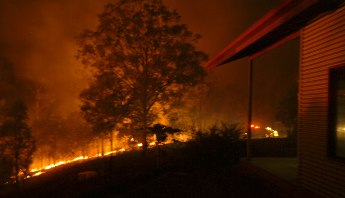
4.45pm – the fire has burned into the National Park to the south of our place
As the fire near the creek-crossing burned along the edge of our track it set alight the bark of a couple of very tall Angophora trees. These are a distant relative of the eucalypts, and this particular species has a thick, cracking and highly flammable bark that can burn for hours. The fire raced up these, reaching a height of 25 metres or more in minutes. Then, for hours burning flakes of bark fell from high in the canopy, breaking up as they fell and drifting with the wind with the potential to land across the track in unburned areas. By this time there were eight or ten fire crews scattered around the area, so we asked one of them to come in and hose down the tree. Of course, even with the pressure from their pumps the jets from their hoses could not reach more than half way up the trees, but at least this reduced the risk quite a lot. In addition they covered the potential drop zone on the other side of the track in foam to reduce the chances of ignition there.

Burning bark of an Angophora on the edge of our track – this shows only abut two-thirds or less of the height to which it was burning.
We arranged for one of the fire crews who were going to stay in the area mopping-up to keep an eye on this during the night and we drove down to check it ourselves every couple of hours until midnight.
In the end it seems most likely that the fire had started somewhere along Lilydale Creek, from a burnt log or dead tree that had been quietly smouldering since the October fire nearly three weeks before, and had flared up in the high temperatures, low humidity and strong winds that day. The same thing had happened a couple of months before in another part of the Hills, and in both cases there had been more than 60mm of rain since the earlier fire. In fact, parts of this fire were still smoking 36 hours later, after more than 100mm of rain had fallen in a four-hour period.


![Spotted Quail-thrush. [Copyright Kevin1234 - Creative Commons Attribution-ShareAlike]](https://lockyervalley.org/wp-content/uploads/2013/04/cinclosoma_castanotus-250a.jpg)


