Tips on bushfire preparedness

There’s a new post at the Helidon Hills Smokespotters website summarising some tips coming out of newly published research from some major wildfires in the western United States and from Ignite Change, a relatively new Australian blog on bushfire awareness.

If you are living in Australia with any kind of bushfire threat, this would be a really good time to start updating and upgrading your bushfire protection, and the links above might just give you some ideas that will increase your property’s survivability.

Other relevant posts:

Fire Danger & Weather Conditions:      My other blog is the website for the Helidon Hills Smokespotters, an informal community group with members located at over 20 locations around the Helidon Hills in the Lockyer Valley.  You can find out about the Smokespotter group here.  The group’s motto is: when it comes to bushfires, we are all neighbours.  Though the group […]

The Fire Danger and Weather Conditions Tab above

Living with and understanding fire risk     Those of us who live on rural properties face varying degrees of fire risk.  Most of us are aware of the risk in a general sort of way, and many of us take active precautions to reduce the risk to some extent.  Few of us, however, think about how the reasons for living where we […]
An unexpected bushfire      The weather last Friday morning was quite unusual.  In fact I was commenting on it at the time in a blog post I was writing over at the Helidon Hills Smokespotters web site.  The general feel of the morning said “Fire Danger”, even though the actual Forest Fire Danger Rating was only High (we have […]

Living with and understanding fire risk

Why do we live here?  What are the risks?

Why do we live here, and how does that relate to the key fire risks and our perception of those risks?

Those of us who live on rural properties face varying degrees of fire risk.  Most of us are aware of the risk in a general sort of way, and many of us take active precautions to reduce the risk to some extent.  Few of us, however, think about how the reasons for living where we do and the things we value about our surroundings affect both the degree of fire risk we face and, often, the extent to which we act to mitigate risk.

Continually reviewing the values that lead us to live where we do, and the risks we face (whether from fire, flood, or just failures in our food production activities), is a part of ensuring sustainability and resilience in both our lifestyle / habitation  the communities in which we live.

The connection between bushfires and our landscape and community values is highlighted in the latest Fire Note (Life on the Edge – Living with Risk) from the Bushfire CRC (Cooperative Research Centre).  This Fire Note summarises some outcomes from the Social construct of fuels in the interface project 1 which was conducted by the Bushfire CRC uner one or their activity themes, Understanding Risk.

Part of the research involved working with property owners to understand what they value in their surroundings, how they perceive their fire risks, and whether these are related. It used the technique of “social-ecological place mapping” to assist landowners to understand what it is that they relate to their landscape

The second part of the research applied a model of factors affecting house losses in NSW bushfires (in much milder weather conditions than those leading to Victoria’s Black Saturday losses) to the 65 properties of the residents who did the place mapping, to calculate a relative estimate of their risk of loss to bushfire.

According to the model, the risk of loss increased: with increasing steepness of slope; where houses were closer together (seven metres apart – but this effect was minimal where houses were further (50 metres) apart (and of course this applies to the buildings on your property too); as the distance to the nearest water body (swimming pools, ponds, dams) increased; and when vegetation cover within the garden (within 20 metres of the house) was high.

The mean predicted probability of house loss for the 65 houses was 0.43, indicating a substantial potential risk should a fire occur (there was considerable variation among the levels of risk of the various properties).  Community and lifestyle values identified by the participants were found to be possible key factors influencing the relative risk of house loss.

There’s a lot more in the report than I can summarise in this short blog post, and I encourage you to read it and the associated reports which are linked here under the heading Key Resources You Should Know About.

This is the 129th Fire Note that the Bushfire CRC has produced. They make informative and compelling reading.  They can be downloaded here, from a list of titles with brief summaries of contents.

And on the home front, it’s time to review and update our fire strategies, and to make sure that they are well documented.  I’ll do a separate post on our strategies in a few weeks.

Lockyer Valley cited as an example of sustainable and resilient action in the face of climate change

There’s an article in The Conversation today on Fire and flood: how home insurance can help us adapt to climate change that refers to the fact that after a natural disaster home insurance allows a home to be replaced on-site on a “like-for-like” basis, and life carries on as usual.  And it’s that “life as usual” aspect of it that is the problem.  The site has the same disaster risk as before and, to the extent that local planning laws allow, the new house has the same risk profile as before.  And house insurance premiums keep climbing because of the risk profile of so much of the housing stock in the face of increasingly extreme weather conditions arising from climate change.

The article suggests that the solution may lie in action taken through the

“… critical relationships that bring together the different players involved in insurance, housing provision, climate adaptation and disaster management.

They will be required to work together with various stakeholders in bravely and innovatively deciding how and where we redesign and build more resilient Australian communities. The plan to relocate homes in the ravaged township of Grantham in the Lockyer Valley is an Australian first and exemplary of how such initiatives might work through land-swaps.

There will be an uncomfortable period of transition; communities in urban areas have an inertia to them that means change is slow. Even as new safe havens pop up, they will not be available to everyone immediately. Weathering our climate change future will require a response that involves all Australians.”

I completely agree, having long thought that we need to use natural disasters as a catalyst for a process that recognises past errors in planning and design and moves, in stages if necessary, to a more sustainable and resilient situation.

Go to

to read the full article by Stewart Williams, University of Tasmania

An unexpected bushfire

The weather last Friday morning was quite unusual.  In fact I was commenting on it at the time in a blog post I was writing over at the Helidon Hills Smokespotters web site.  The general feel of the morning said “Fire Danger”, even though the actual Forest Fire Danger Rating was only High (we have six levels of Fire Danger Rating – Low/Moderate, High, Very High, Severe, Extreme, and Catastrophic).  Over the space of half an hour the temperature had climbed a few degrees C, while the Relative Humidity had dropped about 10%.  This was largely caused by strong dry winds coming in from the north.  On the Smokespotters blog I’d finished the post with a plea to the Smokespotters group members not to be lulled into a false sense of security just because 5,000ha in the southern Helidon Hills had been burned out in a fire in late October – there was still about 30,000ha of bushland unburned.

I haven’t posted anything on that fire yet.  Dealing with the fire took up a whole week, then putting everything back in order here and getting our lives back on track (not to mention recovering from the exhaustion from the previous week) took another week.  But I will post something about it  soon.

Having finished the Smokespotters blog post I took a break for lunch.  Our kitchen bench is by a window that faces south, looking across the western half of our forest down to Lilydale Creek, the Lockyer National Park and the back parts of the blocks of two neighbours and up to a distant ridge.  While we were making lunch there was no sign of smoke, but 15-20 minutes later when we had eaten and came back to clear the bench the view that greeted us was of a dense area of boiling smoke in the vicinity of the Creek.
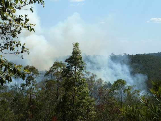
A “zoomed” photo of the fire about 30 minutes after we first saw it, and less than an hour after it started. It now has two clear “fronts”, one driven by the wind and burning strongly in the distance and the other, closer, burning into the rocky bed of Lilydale Creek

My immediate impression was that someone must have lit this.  There is nothing there other than bush, much of it with dense Lantana, and a dam with a water pump at the back of one neighbouring property.  I jumped into my fire-fighting gear (thick canvas jeans, a heavy cotton shirt, and a thick cotton hat) while Hanneke phoned the neighbours whose house was nearest to the fire to alert them and then emergency services on 000 and the local Rural Fire Brigade.  The neighbours were already on their way to investigate.  Like us, they had seen smoke where ten minutes before there had been nothing.  Thinking that they might need help, and also that I might find the ignition point, if not someone who had lit the fire, I grabbed my camera and a Rakhoe (a very effective fire-fighting tool, long-handled, with a wide hoe blade on one side and a coarse rake on the other) and headed toward the fire.

Luckily for me it had burned down into the rocky bed of Lilydale Creek and I was able to cross into the burned area where the fire-front had gone out on against the creek bank.  Navigating largely by the locations of the fire fronts (about 80m on each side) and the slope of the land I came to the neighbour’s fence, luckily at a point where a small section of the fire had burned out against their track, allowing me to cross into the unburned area.

I spent the next couple of hours helping to put out spot fires and checking for embers in and around the house and workshop.  The wind had picked up even more, and there were “floaters” of burning bark and leaves dropping fifty metres or more from the fire front.  We were lucky that they had done a lot of work preparing their property for the fire season, with a number of tracks acting as containment lines, and wide areas of short, mowed grass around the house.  Even so, with the flames periodically blown horizontal by the wind, the fire was easily jumping tracks three metres wide.

In the 38 degreeC heat, low humidity and dry winds patches of grass and leaves which had been extinguished with water were re-igniting within 5-10 minutes.
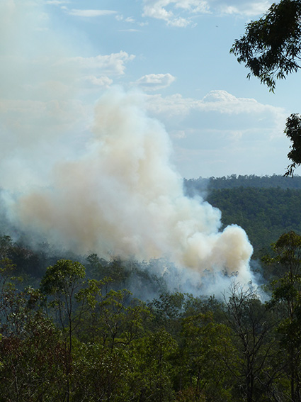
A small section of the fire front about two hours after it started. This was directly up-wind of the neighbours’ house, but by this time there was a fire crew on hand.

No fire trucks were able to reach us for around an hour because it was too dangerous for them to drive through the flame and smoke along the narrow access track. Two volunteer fire-fighters did make it through on foot to check that we were alright.  It must have been a hellish trip through the dense smoke and wind-driven flames.

Two other houses were in the line of the fire after it swept past us, but being closer to the road they were more easily accessible by emergency crews and no damage was done to them.  By the time I was able to get a lift home with one of the neighbours it was late in the afternoon.  On the way, we discovered that the fire had burned about 400 metres against the wind to our access track, and was being monitored by the crew of a fire truck so as to prevent it from getting across into a large area which we had kept the October fire out of.

Arriving back home I discovered that the fire was also making its way up into some areas in the National Park which I hadn’t realised had escaped the October fire.
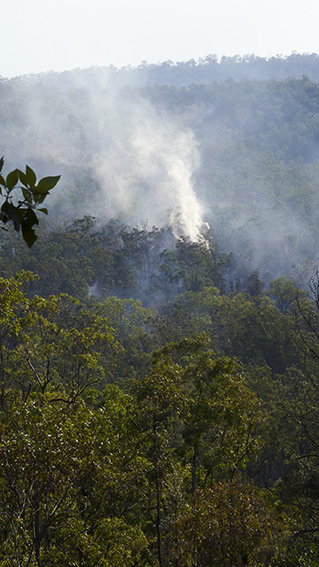
4.45pm – the fire has burned into the National Park to the south of our place

As the fire near the creek-crossing burned along the edge of our track it set alight the bark of a couple of very tall Angophora trees.  These are a distant relative of the eucalypts, and this particular species has a thick, cracking and highly flammable bark that can burn for hours.  The fire raced up these, reaching a height of 25 metres or more in minutes.  Then, for hours burning flakes of bark fell from high in the canopy, breaking up as they fell and drifting with the wind with the potential to land across the track in unburned areas.  By this time there were eight or ten fire crews scattered around the area, so we asked one of them to come in and hose down the tree.  Of course, even with the pressure from their pumps the jets from their hoses could not reach more than half way up the trees, but at least this reduced the risk quite a lot.  In addition they covered the potential drop zone on the other side of the track in foam to reduce the chances of ignition there.

Burning bark of an Angophora on the edge of our track – this shows only abut two-thirds or less of the height to which it was burning.

We arranged for one of the fire crews who were going to stay in the area mopping-up to keep an eye on this  during the night and we drove down to check it ourselves every couple of hours until midnight.

In the end it seems most likely that the fire had started somewhere along Lilydale Creek, from a burnt log or dead tree that had been quietly smouldering since the October fire nearly three weeks before, and had flared up in the high temperatures, low humidity and strong winds that day.  The same thing had happened a couple of months before in another part of the Hills, and in both cases there had been more than 60mm of rain since the earlier fire.  In fact, parts of this fire were still smoking 36 hours later, after more than 100mm of rain had fallen in a four-hour period.

The Soup Kitchen is open again

Following the bushfire (more on this later) that burned out about 80% of our bush 13 days ago, there is very little food for the our wallaby population.  As in the 2009 fire, we have set up a “soup kitchen” to tide them over until enough grass comes through to feed them.

The menu is simple: water (we always put out water pots for them because it is very dry here on the sandstone ridge), pony pellets, and racehorse-grade lucerne (alfalfa).  They much prefer the pony pellets over the lucerne, which is OK with us as the pony pellets cost $10 per bag, while the top-grade lucerne is $10 per bale wholesale and would not last as long as a bag of pony pellets if they decided to eat it.  Any leftover lucerne will make good mulch for the garden.

It’s hard to know how many wallabies we are feeding. They come and go for much of the day and all night, but there are four feeding stations, and there are sometimes 3-4 animals at each at the same time.  Probably nearly half of the females coming to the food are carrying well advanced joeys in their pouches.

Female Red-necked Wallabies at a feeding station

We set up a couple of camera traps (trail cameras) to check whether we are also feeding pigs and deer, but so far there aren’t any signs of them at our feeding stations.  We can see by their tracks that they are moving through our property from the National Park (also burned out) to get to the stone-fruit orchard next door.  The windfall fruit lying on the ground there are a favourite of the pigs, and the succulent leaves on the trees  attract the deer.  Our pony pellets and lucerne probably can’t compete with either of those.

One thing we did discover was that at a certain age the young male Red-necked Wallabies get around in a group.

A “gang” of young males takes over a feeding station.

In addition to checking for feral animals, the camera records provide us with great entertainment in the form of interactions between the wallabies, confrontations they have with possums, and views of joeys (baby wallabies) hanging their heads/tails/legs out of the pouch.

Wallaby vs Possum stand-off

Even the possums get possessive about the feeding stations sometimes.

Mother Brush-tailed Possum defends the feeder (and her young one) from an interloper

Some surprising things get into the camera trap images.  The data on the bottom right of the photo shows date (ddmmyyy) and time.

A bat zooms over one of the feeding stations – possibly a Flying Fox (one of the Megachiroptera).  Its image is distorted by the relatively slow shutter speed.

There is “green pick” coming up already in the burnt areas, and some of the wallabies are starting to feed there, though it would be hard work for a mother with a large joey in the pouch or “at-heel” to get enough of this to sustain herself and the joey.  Some of the females will have a joey at-heel but still getting milk from the mother, another in the pouch, firmly attached to a nipple, and another in the early stages of gestation, and their nutrient needs will be even greater.

We’ve had 69mm of rain since the fire went through, so the grass should come back relatively quickly.  We plan on starting to gradually reduce the food we supply in the next couple of weeks.

Right on time!

We heard the first Channel-billed Cuckoo (Scythrops novaehollandiae) of the season today – 19 September.  In the eight years in which we have recorded their first calls they have occurred on September 7th (1 year), 19th (2), 20th (2), 21st (1), 22nd (1), and 24th (1).  Pretty punctual for a bird that has flown all the way from its winter quarters in southern Indonesia, the Bismarck Archipelago or New Guinea.

These are spectacular birds, unmistakable because of their size, large bill, and the cruciform outline in flight, not to mention their raucous calls.

When they first arrive it is like greeting old friends.  For a few weeks they are more or less discreet, not often heard or seen, but after a while they become more obvious, calling frequently and being chased in mad dashes in and out of the trees by other large birds which are their unwilling hosts.

Eventually they engage in night-long calling sessions, well and truly wearing out their welcome, particularly as they seem to prefer to hold their meetings on ridge tops (our house being situated on a prominent one).

To judge by the species which react to their presence they probably parasitise the local Pied Currawongs, Magpies and Crows.

[photo: Aviceda, from http://en.wikipedia.org/wiki/File:Channel-billed_Cuckoo_Sep07_kobble.jpg creative commons licence]